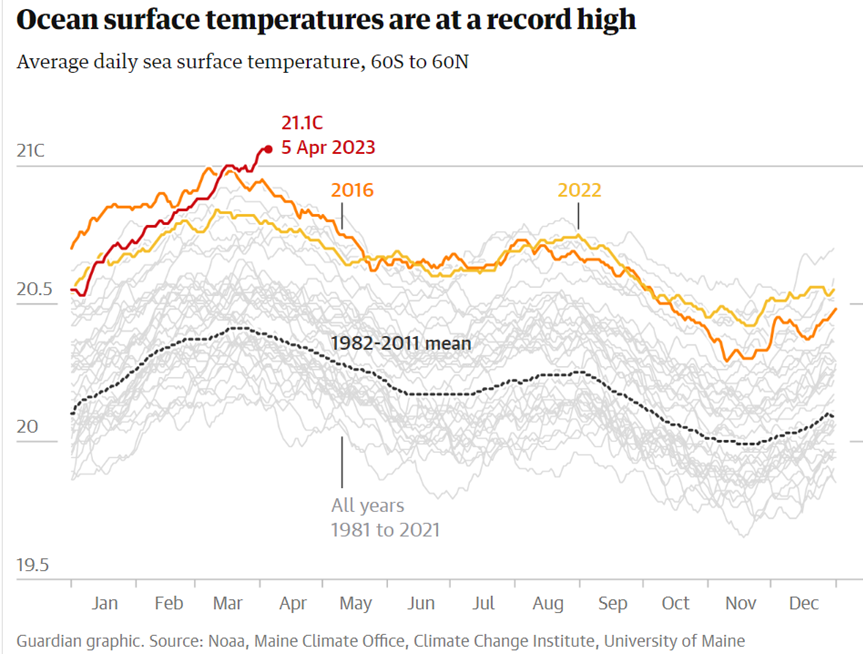
According to data from the National Oceanic and Atmospheric Administration, the global average has been at 21.1°C since the start of April. Climate experts warn this could lead to an increased risk of extreme weather and marine storms.
According to US government data incorporating observations from satellites, ships, and buoys, the temperature of the world’s ocean surface reached 21.1°C at the start of this month, a new high since official records began over four decades ago.
As a result, hurricanes, typhoons, and marine storms may be more powerful than usual this year.
‘We are entering unknown climate and meteorological territory and crossing borders that have never been crossed before,’ says meteorologist Francisco Martín León.
‘Human beings are doping up the atmosphere and oceans with their emissions of greenhouse gases, and this has consequences for the meteorological system.’
Beating the previous figure of 21°C set in 2016, the sea is heating up due to global warming, caused by an increased amount of greenhouse gases in the atmosphere.

The last time a similar level was documented by the National Oceanic and Atmospheric Administration (NOAA), it was driven by the El Niño phenomenon, which cyclically warms the tropical areas of the Pacific Ocean.
During the last three years La Niña – a natural, changing, and opposing event – has kept the water cool, helping suppress temperatures and cushion the repercussions of rising emissions.
Because this ‘triple dip’ anomaly (as it’s referred to by experts) has come to an end, however, a potential El Niño pattern could now occur, bringing with it extreme weather conditions and another hurdle in our fight to combat the climate crisis.


